WHAT I’M WATCHING
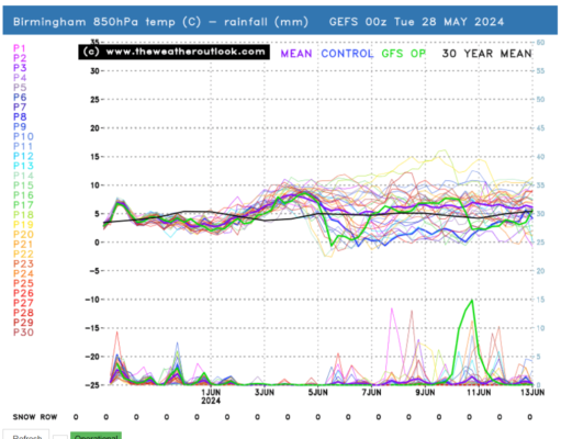
Outlook for the next couple of weeks looking at the GEFS model.
The GEFS graph.
The GEFS graph shows the temperature at 850hpa which is approximately 1,500 metres above ground...
Update on Polar Vortex.
I am continuing to watch the Polar Vortex (PV) with interest. It is looking like later this week will be the...
At the moment it’s still looking wintry on Thursday morning, but very borderline.
I have put three images together from 3 different models the GFS, GEM and ARPEGE and all three are showing snow...
What will storm Jocelyn bring to Cannock Chase.
The UK met Office have named the next storm that is arriving tomorrow Tuesday Jocelyn. It's following much the same...
Update on Sunday’s Storm now named Isha.
I started to talk about the potential of a storm during Sunday several days ago. Now its been named Isha.
Update on Polar Vortex and SSW.
Just before Christmas I wrote about a chance of a Sudden Stratospheric Warming (SSW) on the Polar Vortex around 3rd January....
The GEFS thinks it looks like it’s going to go colder the start of...
The GEFS.
This is the latest GEFS graph model. This model shows the temperature at 850hpa that's 1500...
Update on what is called storm Ciaran by the UK Met Office.
Low pressure system called Ciaran by the UK Met Office.
Last week i said there was a possibility...
Temperatures remaining high cooling off from the start of next week.
The heatwave is set to continue tomorrow and over the weekend. We could see a shower Saturday evening and overnight into...
Outlook for the bank holiday weekend.
Saturday 26th.
Cloudy with heavy showers with a possible rumble of thunder, 17 c.
Sunday...